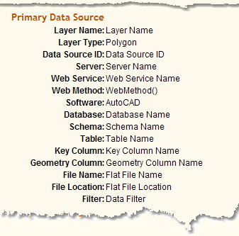
Layer Name:
|
The name used behind the scenes to uniquely identify the name of the layer. It is the same name that is visible to everyone in the Tab Menu - Info tab.
|
Layer Type:
|
Point, line, polygon, etc. It is the same name that is visible to everyone in the Tab Menu - Info tab.
|
Data Source ID:
|
The ID used behind the scenes to identify the source of the data.
|
Server:
|
The name of the physical server.
|
Web Service:
|
The name of the web service used.
|
Web Method:
|
The name of the specific web method used.
|
Software:
|
The source software used to create the data displayed in the mapping window.
|
Database:
|
Oracle or SQL Server database name.
|
Schema:
|
Schema name.
|
Table:
|
Actual database table the data lives in.
|
Key Column:
|
The primary key field name for that data.
|
Geometry Column:
|
The table field name containing the actually geometry information.
|
File Name:
|
The name of the flat file used. For any particular layer the data displayed is either in a database table or a flat file.
|
File Location:
|
The actual folder path of the flat file.
|
Filter:
|
The part of the where clause used to limit what objects are displayed in the mapping window for a layer. For example, Fieldname = 'Some Code'
|