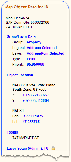
Map Object ID:
|
Typically just the ID of the mapping object. In rare cases it will show multiline information as demonstrated above with an address object.
|
|
|
Group:
|
Mapping file group name. May or may not match the Layer Menu group name.
|
Legend:
|
Mapping file legend name. This is the name the user will see in the Layer Legend when printing an image of the map to paper. May or may not match the Layer Menu legend name.
|
Layer:
|
Mapping file layer name.
|
Type:
|
Type of map object: Text, Point, Polyline, Polygon, etc.
|
Priority:
|
Mapping draw order priority between 1 and 100. The higher the number the higher the drawing order.
For example, two polygon layers having draw priorities of 40 and 50 would display the polygon layer with the 50 on top of the polygon with the draw priority of 40 in the mapping window.
|
|
|
|
Point/Text Object Location
|
X - Y:
|
Arbitrary XY coordinates for a point object corresponding to NAD83/91 WA State Plane, South Zone, US Foot.
|
Lon - Lat:
|
Longitude and Latitude coordinates (in decimal degrees) for a point object using the NAD83 coordinate projection system.
Each point is the insertion point for a text feature in a text layer or a point feature in a point layer.
|
|
|
|
Line/Polygon Object Extents
|
MinMax
X - Y:
|
The minimum and maximum arbitrary XY bounding box coordinate points for a polyline or polygon object corresponding to NAD83/91 WA State Plane, South Zone, US Foot.
|
MinMax
Lon - Lat:
|
The minimum and maximum Longitude and Latitude bounding box coordinate points for a polyline or polygon object (in decimal degrees) using the NAD83 coordinate projection system.
The two bounding box point pairs are located at the bottom left and top right of the map object.
|
|
|
Tooltip:
|
The actual tooltip, or maptip, information displayed in yellow when the user pauses the mouse pointer over the selected object.
|
|
|
Layer Setup:
|
The information here is highly restricted. Only govME personnel and Test Users can view this information. Please see Restricted Access for more on this.
The information here varies depending on the object selected. It contains similar attributes found in the layer's Metadata.
|